Brace Yourself: The Gateway Overlay Zone is Back!

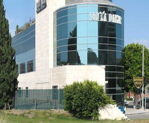
The Beverly Hills Planning Commission will again consider an overlay zone proposal for the former Pacific Electric railroad right-of-way (ROW). We’ve covered this extensively in the past because the railroad land offers our last opportunity to re-imagine the entire Santa Monica Boulevard corridor for something other than motor traffic and banal office uses. In the last March meeting, the commission considered a change in tack toward form-based zoning: tell applicants what we want and let them figure it out. We’ll know it when we see it. Is that good enough? Can’t we find a better use for this land than another building just like this one?

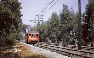
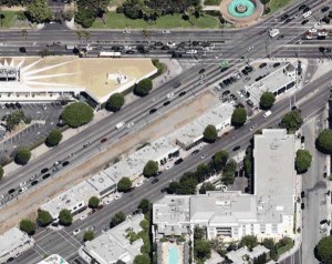
The action concerns three T-1 (transportation) zoned parcels at Santa Monica & Wilshire boulevards.* It is a long and complicated story, but the bottom line (as we’ve reported before) is that both the landowners and the city want to see something built now on the old railroad land because Beverly Hills policymakers dithered for too long. Their ambivalent approach over the last decade has left the land an eyesore. And a real profit opportunity. Except, that is, in the eye of railfans: we like to imagine those old Red Cars sweeping through from West Hollywood across Doheney (below) to the station that used to stand at Canon and Santa Monica.

With an EIR about to be finalized and project designs in the pipeline, the pressing question remains, What exactly should grace our city’s western gateway on this land? And the task for the commission is to answer the thorny question, How do we encourage applicants to provide it? Ah, the devil has always been in the details!
Landowners salivate at the prospect of developing one of the last, large undeveloped parcels left in town for commercial uses. Commissioners want to see aging shops that front SM Blvd. South get a facelift. And planners want to see more-than-ample underground parking (which means that applicants will have to dig deeper into their pockets).

It is a planning puzzle the likes of which we don’t get in planning school. How to encourage good design even if we can’t exactly specify it? How can we ensure that development will proceed in coordinated fashion when it’s all patchwork ownership? And how to ensure that this narrow strip of land – one that stretches to the eastern gateway – retains some of its historic function as a transportation corridor? “We’ll know good design when we see it,” the commissioners say as they set about crafting an overlay zone to encourage development but yet put some limits on the building envelope.
As for the question of transportation use, well there’s no easy answer here. The City Council liaisons last Spring declined to embark on a corridor-wide exercise to imagine the future of Santa Monica Boulevard. With reconstruction of the corridor now pushed back to 2015, time appears to be on our side for a better solution (even if official interest is not).
Yet time is fleeting too. When Gateway comes before the commission next on May 24th, our commissioners will likely move forward to create a form-based overlay zone as discussed in the March meeting. Planners call it building to the vision instead of to prescriptions. But if there’s anything lacking in Beverly Hills it is vision.

But we need not imagine what a renewed Pacific Electric could look like. There are existing examples where communities celebrate the historic transportation function of the Pacific Electric railroad with new uses. In the San Gabriel Valley, for example, the Pacific Electric Inland Empire Trail effort puts human feet to a 20-mile stretch of the old railroad from Claremont to Rialto. In Orange County, an effort is underway to develop 20 miles of the old West Santa Ana Branch for use as a linear park (or even bus rapid transit).
These communities find new transportation uses for old rail lines, so why can’t we? Our task is much easier: work with only a few miles of the old right-of-way that’s right here in our own city. Is it because we can’t take the long-term perspective that we see taking shape in the San Gabriel Valley and Orange County?
Do you have a vision for how this land could be put to a higher and better purpose than, say, yet another business triangle-type banality? Let us know. We’re anxious to fill the ‘vision void’ with something that commissioners can really chew on.
The Nitty Gritty
* The three projects in the Gateway are 9900 Santa Monica and 9848 and 9817 Wilshire Boulevard. The focus is on 9817 Wilshire, which is currently zoned T-1 (Transportation). Adjacent parcels to it are zoned C-3 (commercial). The overlay zone would establish incentives to develop the railroad and commercial land in tandem and it could include either a precise prescription or a more general form-based direction to applicants. At this meeting, the commission will consider a staff recommendation and resolution adopting a revised EIR and creating an overlay zone and set of accompanying conditions that would permit development on the right of way for the first time.

Who makes the final decision on the old RR line land? Of course it would be a great idea as a dedicated bike path. Is there a way to safely connect it to the bhusd campuses?
City Council makes the final decision on all major planning issues, including the overlay zone that will shape development at the city’s western end. The zone will apply only to the old RR line and adjoining properties, so it won’t touch the campuses, but thinking imaginatively about using this land for an active transportation and/or recreation path could be the spine for a larger system.
Imagine that you’re a high school student who lives on north Crescent. You could bike from the HS up Moreno to pick up the new bike lane or path that runs adjacent to the new developments at the Gateway. You could ride it across Wilshire – perhaps with dedicated bike signaling – and connect with a bike lane or sharrows-marked route up Crescent. Or from the HS up Moreno to the Gateway path, across the street through the Hilton property to Whittier, and across on Elevado (which should have a bike route). The old RR land could be tomorrow’s incarnation of its illustrious transportation past…if we had the vision.